MUSIC

Saturday, June 27, 2020

Pride Month in Poland

In Poland, June was the Pride Month - it's about the LGBT community - write in the comments if in your country June is also a Pride Month


******


Legal and social situation of LGBT people in Poland

I won't write straight from Wikipedia this time, there is simply no point. The situation of LGBT people in Poland is critical. In 2020, in the annual ILGA Europe report, Poland was recognized as the most homophobic country in the European Union, taking the last place in terms of LGBT. However, there are more and more people belonging to the LGBT community in Poland from year to year. There is even a special organization for the protection of LGBT persons, and one of the political parties supports the LGBT community. But in the upcoming elections, unfortunately, the presidential candidate from this party unfortunately has 2-3% support, i.e. zero. In other words, Poland will probably never accept the LGBT community. In Poland, weddings and adoption of children by persons belonging to the LGBT community are strictly prohibited.


******


LGBT parades in Poland

Many LGBT parades are organized in Poland, where many people gather every year. They are usually larger cities, such as Warsaw and Poznań, less often in smaller ones. In total, a lot of equality marches were organized in Poland from 2001 to 2019, maybe even around 100. Unfortunately, it should be mentioned that a lot of critics gather behind pride marches, sometimes even accidents occur among critics, LGBT people, or even police, who keeps order on pride marches. Several other festivals for LGBT people are also organized in Poland.


******


English-Polish mini glossary

I will translate a few words related to LGBT


LGBT (ang. Lesbian, Gay, Bisexual, Transgender) - in Polish: Lesbijki, Geje, Biseksualizm, Transpłuciowcy, so also LGBT in short

Homophobic - Homofobia

Homosexualism/Homosexual - Homoseksualizm/Homoseksualista

Asexualism/Asexual - Aseksualizm/Aseksualista

Bisexualism/Bisexual - Biseksualizm/Biseksualista

Intergender - Interpłciowość

Non-binary persons - osoby niebinarne

Pansexualism/Pansexual - Panseksualizm/Panseksualista

Genderqueer - Niebinarność/Niebinarne tożsamości płciowe or, we speak this word also in English so simply "genderqueer"

Genderfluid or Agender - Agenderyzm/Arodzajowość. "A" - lack/deny, gender(yzm), borrowed from English

Polysexualism/Polysexual - Poliseksualizm/Wielopłciowiec
Polyamorous - Wielokolorowy

Androphilia - Androfilia

Gynephilia - Gynefilia

Lithsexualism/Lithsexual - Litseksualizm/Litseksualista

Autosexualism/Autosexual - Autoseksualizm/Autoseksualista

Demisexualism/Demisexual - Demiseksualizm/Demiseksualista

Bear - Miśki

Straight ally - Prosty sojusznik

Pride Month - Miesiąc dumy

June - czerwiec

Parade - parada

Equality - Równość

Equality Parade - Parada Równości

march - marsz

The words "sexual", "sexualism" and "phobia" in Polish are read the same as in English

sexual - seksualista

sexualism - seksualizm

phobia - fobia


******


Polish meanings of colors on the main LGBT community flag


pink/sexuality - różowy/seksualność
red/life - czerwony/życie
orange/cure - pomarańczowy/uzdrowienie
yellow/Sun - żółty/słońce
green/nature - zielony/natura
blue/art - niebieski or błękitny/sztuka
navy blue/harmony - ciemnoniebieski/harmonia
purple/spirituality - fioletowy/duchowość

Now, however, pink is omitted


******


What do I think about LGBT?

Once I would certainly look at it in disgust. But now... I actually support LGBT people. Unfortunately, my parents are terrible homophobic people and certainly if I told them that I was, for example - bisexual - them would be angry, I hope that they wouldn'tt tell me to be treated. I think that LGBT people are also people, and the fact that they prefer, for example, a different gender or want to look different doesn'tt mean that they are sick, abnormal, they are normal people, they as we live, eat, have physiological needs, want to educate, work and live in old age in their own way. I'm begging you, do not criticize them, because it only shows how childish and irresponsible you YOU ALL act, criticizing people who are different from you. I'm not saying you must be friend LGBT people, just don't criticize them! I say this not only to Poles, but also to other people from around the world who are just waiting for a moment to criticize someone from the LGBT community.


******


There would certainly be more to say, but it would take a long time to write


Here is the links to Wikipedia:


CREDITS TO ARTSIT for articles from Wikipedia

This entry was not intended to offend the current policy of Poland, the ruling party, nor the president, the government and LGBT intolerant people.

Wednesday, June 24, 2020

Father's Day in Poland

Father's Day was celebrated today in Poland
This day, like Mother's or Child's Day, is celebrated on another day in the world. As for June 23, it is only in Poland and Nicaragua. In the US, it is celebrated on the third Sunday of June, in Russia on February 23, in Indonesia on November 12, etc.

So if you already had father's day, I hope your dad got a present or something, or if you haven't had it yet try to for father


******


HISTORY AND TRADITIONS

In Poland, Father's Day isn't a public holiday.

Customs during Father's Day it to give fathers wishes and give them small gifts, so the same as for example Mother's Day.

Basically, I don't have much to write here. I'm sorry


******


TERMS RELATED TO FATHER'S DAY - MINI ENGLISH-POLISH GLOSSARY

Father - Ojciec
Father's Day - Dzień Ojca
June 23 - 23 czerwca
Dad - Tata
Daddy - Tatuś
Wishes - Życzenia


******


I know that it isn't much written, but I think that I have already compensated you with earlier posts with descriptions of voivodeships

Tuesday, June 23, 2020

16. Opole Voivodeship (Polish: Opolskie)

This is the last voivodeship in Poland. Today will be a slightly different post, and the weekend will be next


******


16. OPOLE


Opole Voivodeship, or Opole Province (PL: Województwo opolskie) - is the smallest and least populated voivodeship (province) of Poland. The province's name derives from that of the region's capital and largest city, Opole. It is part of Upper Silesia. A relatively large German minority, with representatives in the Sejm, lives in the voivodeship, and the German language is co-official in 28 communes.

Opole Voivodeship is bordered by Lower Silesian Voivodeship to the west, Greater Poland and Łódź Voivodeships to the north, Silesian Voivodeship to the east, and the Czech Republic (Olomouc Region and Moravian-Silesian Region) to the south.

Opole Province's geographic location, economic potential, and its population's level of education make it an attractive business partner for other Polish regions (especially Lower Silesian and Silesian Voivodeships) and for foreign investors. Formed in 1997, the Praděd/Pradziad Euroregion has facilitated economic, cultural and tourist exchanges between the border areas of Poland and the Czech Republic.


Only in Polish


Flag


Coat of arms


******


HISTORY

Opole Voivodeship was created on January 1, 1999, out of the former Opole Voivodeship and parts of Częstochowa Voivodeship, pursuant to the Polish local government reforms adopted in 1998. Originally, the government, advised by prominent historians, had wanted to disestablish Opolskie and partition its territory between the more historically Polish regions of Lower Silesia and Silesian Voivodeship (eastern Upper Silesia and western Lesser Poland. The plan was that Brzeg and Namysłów, as the Western part of the region, were to be transferred to Lower Silesia, while the rest was to become, along with a part of the Częstochowa Voivodeship, an integral part of the new 'Silesian' region. However, the plans resulted in an outcry from the German minority population of Opole Voivodeship, who feared that should their region be abolished, they would lose all hope of regional representation (in the proposed Silesian Region, they would have formed a very small minority among a great number of ethnic Poles). To the surprise of many of the ethnic Germans in Opole however, the local Polish Silesian population and groups of ethnic Poles also rose up to oppose the planned reforms; this came about as a result of an overwhelming feeling of attachment to the voivodeships that were scheduled to be 'redrawn', as well as a fear of 'alienation' should one find themselves residing in a new, unfamiliar region.

The solution came in late 1999, when Olesno was, after 24 years apart, finally reunited with the Opole Voivodeship to form the new legally defined region. A historic moment came in 2006 when the town of Radłów changed its local laws to make German, alongside Polish, the district's second official language; thus becoming the first town in the region to achieve such a feat.


******


GEOGRAPHY

The voivodeship lies in southwestern Poland, the major part on the Silesian Lowland (PL: Nizina Śląska). To the east, the region touches upon the Silesian Upland (PL: Wyżyny Śląskie, Wyżyna Śląska) with the famous Saint Anne Mountain (PL: Góra Świętej Anny); the Sudetes range (PL: Pasmo Sudetów), the Opawskie Mountains (PL: Góry Opawskie), lies to the southwest. The Oder River (PL: Rzeka Odra) cuts across the middle of the voivodeship. The northern part of the voivodeship, along the Mała Panew River, is densely forested, while the southern part consists of arable land.


PROTECTED AREAS

Protected areas in Opole Voivodeship include the following three areas designated as Landscape Parks:
  • Opawskie Mountains Landscape Park
  • Góra Świętej Anny Landscape Park
  • Stobrawa Landscape Park

CLIMATE

Climate data of Opole

 Month Average high °C (°F) Average low °C (°F)
 January 2 (36) -3 (27)
 February 3 (37) -3 (27)
 March 8 (46) 0 (32)
 April 15 (59) 4 (39)
 May 20 (68) 8 (46)
 June 22 (72) 11 (52)
 July 25 (77) 14 (57)
 August 25 (77) 14 (57)
 September 20 (68) 10 (50)
 October 15 (59) 5 (41)
 November 8 (46) 1 (34)
 December 3 (37) -2 (28)
 Year 13.8 (56.8) 4.9 (40.8)

The region has the warmest climate in the country.


******


ADMINISTRATIVE DIVISON

Opole Voivodeship is divided into 12 counties (powiats): 1 city county and 11 land counties. These are further divided into 71 gminas.

The counties are listed in the following table (ordering is by decreasing population).

You must zoom in to have good quality


******


CITIES AND TOWNS

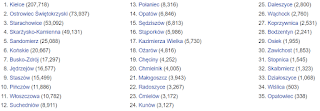
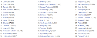
The voivodeship contains 36 cities and towns. These are listed below in descending order of population (as of 2019):

You must zoom in to have good quality


******


DEMOGRAPHY

The Opole Voivodeship is the smallest region in the administrative makeup of the country in terms of both area and population.

About 15% of the one million inhabitants of this voivodeship are ethnic Germans, which constitutes 90% of all ethnic Germans in Poland. As a result, many areas are officially bilingual and the German language and culture play a significant role in education in the region. Ethnic Germans first came to this region during the Late Middle Ages. The area was once part of the Prussian province of Silesia.


******


ECONOMY

The Gross domestic product (PKB) of the province was 10.1 billion euros in 2018, accounting for 2.0% of Polish economic output. PKB per capita adjusted for purchasing power was 17,000 euros or 56% of the EU27 average in the same year. The PKB per employee was 66% of the EU average.

The Opole Voivodeship is an industrial as well as an agricultural region. With respect to mineral resources, of major importance are deposits of raw materials for building: limestone (Strzelce Opolskie), marl (near Opole), marble, and basalt. The favourable climate, fertile soils, and high farming culture contribute to the development of agriculture, which is among the most productive in the country.

A total of nineteen industries are represented in the voivodeship. The most important are cement and lime, furniture, food, car manufacturing, and chemical industries. In 1997, the biggest production growth in the area was in companies producing wood and wood products, electrical equipment, machinery and appliances, as well as cellulose and paper products. In 1997, the top company in the region was Zakłady Azotowe S.A. in Kędzierzyn-Koźle, whose income was over PLN 860 million. The voivodship's economy consists of more than 53,000 businesses, mostly small and medium-sized, employing over 332,000 people. Manufacturing companies employ over 89,000 people; 95.7% of all the region's business operate in the private sector.

TOURISM

The Opole Voivodeship is a green region with three large lakes: Turawskie, Nyskie, and Otmuchów (the latter two are connected). The Opawskie Mountains are extremely popular. The region also includes the castle in Brzeg, built during the reign of the Piast dynasty—pearl of the Silesian Renaissance, the Franciscan monastery on top of Saint Anne Mountain, as well as the medieval defence fortifications in Paczków (referred to as the Upper Silesian Carcassonne).

INTERNATIONAL TOURISM

According to the Central Statistical Office of Poland, Opole Voivodeship is most frequently visited by international tourists from countries located in Europe (94.6%). The rank was followed by tourists from Asia, compromising 2.4% of the total international tourist figure, followed by that of North America at 1.8%. The general composition of international tourists visiting the Opole Voivodeship remains unchanged, with 46.2% of tourists heading from Germany.

In 2015, a total of c. 90,800 overnight stays were hosted for international tourists, a figure making up 12.4% of the total amount of overnight stays for Opole Voivodeship. The majority (44.7%) of international overnight stays were hosted in the city of Opole, followed by Kędzierzyn-Koźle County (9.9%) and Nysa County at (9.4%).


******


TRANSPORTATION

The transport route from Germany to Ukraine, the A4, runs through Opole. The region has four border crossings, and direct rail connections to all important Polish cities, as well as to Frankfurt, Munich, Budapest, Kiev, and the Baltic ports.


******


UNIVERSITIES

There are three state-run universities in the region: the Opole University, the Opole University of Technology, and the Public Higher Medical Professional School in Opole. All of them are based in the voivodeship's capital. Among the region's private schools, the Opole School of Management and Administration has been certified as a degree-granting institution by the Ministry of National Education.

  • Opole University of Technology
  • Opole University
  • State Medical College
  • Opole School of Management and Administration
  • Bogdan Jański College
  • The State Higher Vocational School in Nysa, PWSZ in NYSA


******


MOST POPULAR SURNAMES IN OPOLE VOIVODESHIP

  1. Nowak: 5,538
  2. Wieczorek: 2,654
  3. Mazur: 2,512


******


FORMER OPOLE VOIVODESHIPS

1975-1999

Opole Voivodeship was also a unit of administrative division and local government in Poland between 1975 and 1998.

Major cities and towns (population in 1995):

  1. Opole, capital city (130,600)
  2. Kędzierzyn-Koźle (70,700)
  3. Nysa (49,000)
  4. Brzeg (39,900)
  5. Kluczbork (26,900)
  6. Prudnik (24,300)
  7. Strzelce Opolskie (21,900)
  8. Krapkowice (20,100)

1950-1975

This administrative region of the People's Republic of Poland (1950–1975) was created as a result of the partition of Katowice Voivodeship in 1950.


******


More information and photos here:


CREDIT TO ARTIST for photos and articles from Wikipedia

Friday, June 19, 2020

15. Holy Cross Voivodeship (Polish: Świętokrzyskie)

I described these three voivodeships that I published today very quickly. On Sunday, Monday or Tuesday, idk - I will publish the last voivodeship


******


15. HOLY CROSS

Świętokrzyskie Voivodeship, Świętokrzyskie Province, or Holy Cross Province (PL: Województwo świętokrzyskie) - is one of the 16 voivodeships (provinces) into which Poland is divided. It is situated in southeastern Poland, in the historical region of Lesser Poland, and takes its name from the Świętokrzyskie (Holy Cross) mountain range. Its capital and largest city is Kielce.

Świętokrzyskie Province is bounded by six other voivodeships: Masovian to the north, Lublin to the east, Subcarpathian to the southeast, Lesser Poland to the south, Silesian to the southwest and Łódź to the northwest.

The province was created on 1 January 1999, out of the former Kielce Voivodeship, eastern part of Częstochowa Voivodeship and western part of Tarnobrzeg Voivodeship, pursuant to the Polish local government reforms adopted in 1998. It covers an area of 11,672 square kilometres (4,507 sq mi), making it the second smallest of the voivodeships (after Opole). As at 2006, the total population of Świętokrzyskie Voivodeship is 1,281,796.

Only in Polish


Flag

Coat of arms


******


CITIES AND TOWNS

The voivodeship contains 32 cities and towns. These are listed below in descending order of population (according to official figures for 2006):

You must zoom in to have good quality


******


ADMINISTRATIVE DIVISION

Świętokrzyskie Voivodeship is divided into 14 counties (powiats): 1 city county and 13 land counties. These are further divided into 102 gminas.

The counties are listed in the following table (ordering within categories is by decreasing population).

You must zoom in to have good quality


******


ECONOMY

The Gross domestic product (PKB) of the province was 11.6 billion € in 2018, accounting for 2.3% of the Polish economic output. PKB per capita adjusted for purchasing power was 15,400 € or 51% of the EU27 average in the same year. The PKB per employee was 58% of the EU average. Świętokrzyskie Voivodship is the province with the fifth lowest PKB per capita in Poland.


******


PROTECTED AREAS

Protected areas in Świętokrzyskie Voivodeship include one National Park and nine Landscape Parks. These are listed below.

  • Świętokrzyski National Park
  • Chęciny-Kielce Landscape Park
  • Cisów-Orłowiny Landscape Park
  • Jeleniowska Landscape Park
  • Kozubów Landscape Park
  • Nida Landscape Park
  • Przedbórz Landscape Park - partly in Łódź Voivodeship
  • Sieradowice Landscape Park
  • Suchedniów-Oblęgorek Landscpae Park
  • Szaniec Landscape Park


******


More information and photos here:


CREDITS OF ARTIST for photos and articles from Wikipedia

14. Subcarpatian Voivodeship

OMG. I'm going to an apprenticeship for 8:00 PM tomorrow... I don't like working in gastronomy 😭


******


14. SUBCARPATIAN

Subcarpathian Voivodeship
or Subcarpathia Province, also know as Podkarpackie Voivodeship or Podkarpackie Province (PL: Województwo podkarpackie) - is a voivodeship, or province, in southeastern corner of Poland. Its administrative capital and largest city is Rzeszów. Along with the Marshall, it is governed by the Subcarpathian Regional Assembly. Historically, most of the province's territory was part of the Kingdom of Galicia–Volhynia, the Kingdom of Galicia and Lodomeria and the Ruthenian Voivodeship. In the interwar period, it was part of the Lwów Voivodeship.

The voivodeship was created on January 1, 1999 out of the former Rzeszów, Przemyśl, Krosno and (partially) Tarnów and Tarnobrzeg Voivodeships, pursuant to the Polish local-government reforms adopted in 1998. The name derives from the region's location near the Carpathian Mountains, and the voivodeship comprises areas of two historic regions of Eastern Europe — Lesser Poland (western and northwestern counties) and Red Ruthenia. During the interwar period (1918-1939), Subcarpathian Voivodeship belonged to "Poland B", the less-developed, more rural parts of Poland. To boost the local economy, the government of the Second Polish Republic began in the mid-1930s a massive program of industrialization, known as the Central Industrial Region. The program created several major armament factories, including PZL Mielec, PZL Rzeszów, Huta Stalowa Wola, and factories in other Subcarpathian towns such as Dębica, Nowa Dęba, Sanok, Tarnobrzeg and Nowa Sarzyna.

It is bordered by Lesser Poland Voivodeship to the west, Świętokrzyskie Voivodeship to the north-west, Lublin Voivodeship to the north, Ukraine (Lviv Oblast and Zakarpattia Oblast) to the east and Slovakia (Prešov Region) to the south. It covers an area of 17,844 square kilometres (6,890 sq mi), and has a population of 2,096,971 (as at 2006). The voivodeship is mostly hilly or mountainous (see Bieszczady, Beskidy); its northwestern corner is flat. It is one of the most wooded Polish voivodeships (35.9% of total area), within its borders there is whole Bieszczady National Park, and parts of Magura National Park.


Only in Polish


Flag

Coat of arms


******


CITIES AND TOWNS

The voivodeship contains 50 cities and towns. These are listed below in descending order of population (according to official figures as of 30 June 2008):

You must zoom in to have good quality


******


ADMINISTRATIVE DIVISION

Subcarpathian Voivodeship is divided into 25 counties (powiats): 4 city counties and 21 land counties. These are further divided into 160 gminas.

The counties are listed in the following table (ordering within categories is by decreasing population).

You must zoom in to have good quality


******


PROTECTED AREAS

Protected areas in Subcarpathian Voivodeship include two national parks and 11 Landscape Parks. These are listed below.

  • Bieszczady National Park - part of the East Carpathian Biosphere Reserve
  • Magura National Park - partly in Lesser Poland Voivodeship
  • Cisna-Wetlina Landscape Park
  • Czarnorzeki-Strzyżów Landscape Park
  • Jaśliska Landscape Park
  • Janów Forests Landscape Park - partly in Lublin Voivodeship
  • Pasmo Brzanki Landscape Park - partly in Lesser Poland Voivodeship
  • Pogórze Przemyskie Landscape Park
  • Puszcza Solska Landscape Park - partly in Lublin Voivodeship
  • San Valley Landscape Park
  • Słonne Mountains Landscape Park
  • South Roztocze Landscape Park - partly in Lublin Voivodeship


******


ECONOMY

The Gross domestic product (PKB) of the province was 19.4 billion euros in 2018, accounting for 3.9% of Polish economic output. PKB per capita adjusted for purchasing power was 15,100 euros or 50% of the EU27 average in the same year. The PKB per employee was 59% of the EU average. Podkarpackie Voivodship is the province with the third lowest PKB per capita in Poland.


******


ETHNIC GROUPS

POLES:

  • Pogorzans

UKRAINIANS

  • Lemkos
  • Boykos


******


MOST POPULAR SURNAMES IN THE REGION

  1. Mazur - 9,530
  2. Nowak - 9,301
  3. Baran - 8,020


******


NOTABLE RESIDENTS

  • Moe Drabowsky - American major league baseball pitcher


******


More information, photos and links in the history section here:


CREDITS TO ARTIST for photos and articles from Wikipedia

13. Lublin Voivodeship

Fortunately, only this voivodeship and three others to describe. I didn't want to write anymore 😂

Oh no, they changed the font size. And now it is much smaller than it was, sorry ;-;


******


13. LUBLIN

Lublin Voivodeship, or Lublin Province (PL: Województwo lubelskie) - is a voivodeship, or region, located in southeastern Poland. It was created on January 1, 1999, out of the former Lublin, Chełm, Zamość, Biała Podlaska and (partially) Tarnobrzeg and Siedlce Voivodeships, pursuant to Polish local government reforms adopted in 1998. The region is named after its largest city and regional capital, Lublin, and its territory is made of four historical lands: the western part of the voivodeship, with Lublin itself, belongs to Lesser Poland, the eastern part of Lublin Area belongs to Red Ruthenia, and the northeast belongs to Polesie and Podlasie.


Lublin Voivodeship borders Subcarpathian Voivodeship to the south, Holy Cross Voivodeship to the south-west, Masovian Voivodeship to the west and north, Podlaskie Voivodeship along a short boundary to the north, Belarus (Brest Region) and Ukraine (Lviv Oblast and Volyn Oblasts) to the east. The region's population as of 2006 was 2,175,251. It covers an area of 25,155 square kilometres (9,712 sq mi).

Only in Polish


Flag


Coat of arms


******


HISTORY

The Polish historical region that encompasses Lublin, and approximates Lublin Voivodeship as it was before the Partitions of Poland, is known as Lubelszczyzna. Provinces centred on Lublin have existed throughout much of Poland's history.

The region was, before World War II, one of the world's leading centres of Judaism. Before the middle of the 16th century, there were few Jews in the area, concentrated in Lublin, Kazimierz Dolny, and perhaps Chełm; but the founding of new private towns led to a large movement of Jews into the region to develop trade and services. Since these new towns competed with the existing towns for business, there followed a low-intensity, long-lasting feeling of resentment, with failed attempts to limit the Jewish immigration. The Jews tended to settle mostly in the cities and towns, with only individual families setting up businesses in the rural regions; this urban/rural division became another factor feeding resentment of the newly arrived economic competitors. By the middle of the 18th century, Jews were a significant part of the population in Kraśnik, Lubartów and Łęczna.

By the 20th century, Jews represented greater than 70% of the population in eleven towns and close to 100% of the population of Laszczów and Izbica. From this region came both religious figures such as Mordechai Josef Leiner of Izbica, Chaim Israel Morgenstern of Puławy, and Motele Rokeach of Biłgoraj, as well as famous secular authors Israel Joshua Singer. Israel's brother, the Nobel prize winner Isaac Bashevis Singer, was not born in Biłgoraj but lived part of his life in the city. The "Old Town" of the city of Lublin contained a famous yeshiva, Jewish hospital, synagogue, cemetery, and kahal, as well as the Grodzka Gate (known as the Jewish Gate).

Before the war, there were 300,000 Jews living in the region, which became the site of the Majdanek concentration camp and Bełżec extermination camp as well as several labour camps (Trawniki, Poniatowa, Budzyn, Puławy, Zamość, Biała Podlaska, and the Lublin work camps Lipowa 7 camp , Flugplatz, and Sportplatz) which produced military supplies for the Wehrmacht and Luftwaffe). This was once one of the biggest forced labour centres in occupied Europe, with approximately 45,000 Jewish prisoners. As well, the Sobibór extermination camp was located in the Lublin Voivodeship. After the war, the few surviving Jews largely left the area; today there is some restoration of areas of Jewish historical interest, and a surge of tourism by Jews seeking to view their families' historical roots.


******


CITIES AND TOWNS

The voivodeship contains 42 cities and towns. These are listed below in descending order of population (according to official figures for 2006):

You must zoom in to have good quality


******


ADMINISTRATIVE DIVISION

Lublin Voivodeship is divided into 24 counties (powiats): 4 city counties and 20 land counties. These are further divided into 213 gminas.

The counties are listed in the following table (ordering within categories is by decreasing population).

You must zoom in to have good quality


******


PROTECTED AREAS

Protected areas in Lublin Voivodeship include two National Parks and 17 Landscape Parks. These are listed below.
  • Polesie National Park (this and surrounding areas form the West Polesie biosphere reserve designated by UNESCO in 2002)
  • Roztocze National Park
  • Chełm Landscape Park
  • Janów Forests Landscape Park - partly in Subcarpatian Voivodeship
  • Kazimierz Landscape Park
  • Kozłówka Landscape Park
  • Kransobród Landscape Park
  • Łęczna Lake District Landscape Park
  • Podlaskie Bug Gorge Landscape Park - partly in Masovian Voivodeship
  • Polesie Landscape Park
  • Puszcza Solska Landscape Park - partly in Subcarpatian Voivodeship
  • Skierbieszów Landscape Park
  • Sobibór Landscape Park
  • South Roztocze Landscape Park - partly in Subcarpatian Voivodeship
  • Strzelce Landscape Park
  • Szczebrzeszyn Landscape Park
  • Wieprz Landscape Park
  • Wrzelowiec Landscape Park


******


ECONOMY

The Gross domestic product (PKB) of the province was 18.5 billion euros in 2018, accounting for 3.7% of Polish economic output. PKB per capita adjusted for purchasing power was 14,400 euros or 48% of the EU27 average in the same year. The PKB per employee was 54% of the EU average. Lublin Voivodship is the province with the lowest PKB per capita in Poland.


******


MOST COMMON SURNAMES IN THE REGION

  1. Wójcik - 12,937
  2. Mazurek - 9,644
  3. Mazur - 8,019


******


PREVIOUS LUBLIN VOIVODESHIP

1474-1795


1816-1837

Lublin Voivodeship was one of the voivodeships of Congress Poland. It was formed in 1816 from Lublin Department, and in 1837 was transformed into Lublin Governorate.

1919-1939


1945-1975

Lublin Voivodeship was an administrative region of Poland between 1945 and 1975. In 1975 it was transformed into Chełm, Zamość, Biała Podlaska, Tarnobrzeg and Siedlce Voivodeships and a smaller Lublin Voivodeship.

1975-1998

Lublin Voivodeship existed as one of Poland's 49 voivodeships from 1975 until 1998, when it was incorporated into the current (larger) Lublin Voivodeship.


******


More information and photos here:


CREDITS TO ARTIST for photos and articles from Wikipedia

Tuesday, June 16, 2020

12. Podlachian Voivodeship

In this post I will also translate much less names


******


12. PODLACHIAN

Podlachian Voivodeship or Podlaskie Voivodeship, or Podlasie Provinve (PL: Województwo podlaskie) - is a voivodeship (province) in northeastern Poland. It borders on Masovian Voivodeship to the west, Warmian-Masurian Voivodeship to the northwest, Lublin Voivodeship to the south, the Belarusian Voblasts of Grodno and Brest to the east, the Lithuanian Counties of Alytus and Marijampolė to the northeast, and the Kaliningrad Oblast of Russia to the north.

The capital of Podlasie Province is Białystok. The province was created on 1 January 1999, pursuant to the Polish local government reforms adopted in 1998, from the former Białystok and Łomża Voivodeships and the eastern half of the former Suwałki Voivodeship.


Only in Polish


Flag


Coat of amrs


******


ETYMOLOGY

The voivodeship takes its name from the historic region of Poland called Podlasie.

There are two opinions regarding the origin of the region's name. People often derive it from the Slavic les or las, meaning "forest", i.e., it is an area "by the wood(s)" or an "area of forests", which would bring Podlasie close in meaning to adjacent Polesia. This theory has been questioned, as it does not properly take into consideration the vowel shifts "a" > "e" > "i" in various Slavic languages (in fact, it mixes vowels from different languages). Heavily wooded Podlasie is home to the primeval Białowieża Forest and National Park, habitat of the European wisent bison and tarpan.

A second view holds that the term comes from the expression pod Lachem, i.e., "under the Poles" (Lechia). Some claim it to mean "under Polish rule", which does not seem historically sound, as the area belonged to the Grand Duchy of Lithuania until 1569, and the southern part of it—until 1795.

A better variant of the latter theory holds that the name originates from the period when the territory was within the Trakai Voivodeship of the Grand Duchy of Lithuania, along the border with Mazovia Province, primarily a fief of the Poland of the Piasts, and later part of the Kingdom of Poland of the Jagiellons. Hence pod Lachem would mean "near the Poles", "along the border with Poland". The historical Lithuanian name of the region, Palenkė, has exactly this meaning.


******


HISTORY

The voivodeship was created on January 1, 1999, out of the former Białystok and Łomża Voivodeships and the eastern half of the former Suwałki Voivodeship, pursuant to the Polish local government reforms adopted in 1998.


******


GEOGRAPHY

It has a varied landscape, shaped in the north by Baltic glaciation, the rest by Middle Poland glaciation. The highest peaks are in the north (Rowelska Top - 298 m), where the landscape is dominated by a hilly lake district. Lakeland: Zachodniosuwalskie, Wschodniosuwalskie, Ełckie) and Sandrowy lake district (Augustów Plain) in the central and southern pre-glacial plains prevail (plateaus: Kolneńska, Białystok, Wysokomazowiecka, Drohiczynska, Sokólskie Hills, Międzyrzecko łomżyński, Plain Bielsko), varied in topography with small basins and river valleys. Kurpie lie on the west edge of the outwash plains. Sand, gravel, clay, moraine, and in the valleys and basins of the rivers silt, sand and river peat predominate on the surface.


******


ENVIRONMENT

The vast forests (Białowieża, Augustów, Knyszyń, Kurpiowska), some of which are the only ones in Europe to have retained their original character, contain a unique wealth of flora and fauna. The vegetation of the region is extremely diverse, which contributes to the richness of the animal world. Visitors can also see moose, wolves, lynx and bison living in the Białowieża Forest and Knyszyń Forest.

Podlachian has the lowest population density of the sixteen Polish voivodeships, and its largely unspoiled nature is one of its chief assets. Around 30% of the area of the voivodeship is under legal protection. The Polish part of the Białowieża Forest biosphere reserve (also a World Heritage Site) is in Podlaskie. There are four National Parks (Białowieża, Biebrza, Narew and Wigry), three Landscape Parks (Knyszyń Forest, Łomża and Suwałki), 88 nature reserves, and 15 protected landscape areas. The voivodeship constitutes a part of the ecologically clean area known as "the Green Lungs of Poland" (PL: "Zielone Płuca Polski").


******


CLIMATE

Podlaskie has a Warm Summer Continental or Hemiboreal climate (Dfb) according to the Köppen climate classification system, which is characterized by warm temperatures during summer and long and frosty winters. It is substantially different from most of the other Polish lowlands. The region is one of the coldest in Poland, with the average temperature in January being −5 °C (23 °F). The average temperature in a year is 7 °C (45 °F). The number of frost days ranges from 50 to 60, with frost from 110 to 138 days and the duration of snow cover from 90 to 110 days. Mean annual rainfall values oscillate around 550 millimetres (21.7 in), and the vegetation period lasts 200 to 210 days.

Podlachian is the coldest region of Poland, located in the very northeast of the country near the border with Belarus and Lithuania. The region has a continental climate which is characterized by high temperatures during summer and long and frosty winters. The climate is affected by the cold fronts which come from Scandinavia and Siberia. The average temperature in the winter ranges from -15 °C (5 °F) to -4 °C (24.8 °F).


******


SUBDIVISIONS AND BIAŁYSTOK METROPOLITAN REGION


******


DEMOGRAPHICS

Podlachian is the land of the confluence of cultures – Polish, Belarusian, Ukrainian and Lithuanian – and is indicative of the ethnic territories limits. Eastward of Podlaskie lie historic Polish lands, which are now part of Ukraine and Belarus and Lithuania. Today, mainly Polish and Ruthenian (Ukrainian and Belarusian) are spoken in Podlaskie, while Lithuanian is preserved by the small but compact Lithuanian minority concentrated in the Sejny County.

At the end of 2009 in Podlaskie Voivodeship there were 1,189,700 inhabitants, 3.1 per cent of the total population of Poland. The average density of the population, the number of the population per 1 km2, was 59. The urban population in the same period was 60.2 per cent of the total number of inhabitants of the voivodeship, where the percentage of females in the total population amounted to 51.3 per cent. A statistical inhabitant of Podlasie was 37.7 years old, whereas in 2008 – 37.5 years old. The latest population projection predict consistent decrease in the population in Podlaskie Voivodeship. In the next 26 years it will decrease by 117 thousand persons due to the aging of the population.


******


ECONOMY

The Gross domestic product (PKB) of the province was around 11 billion euros in 2018, accounting for 2.2% of Polish economic output. PKB per capita adjusted for purchasing power was €15,200 or 50% of the EU average in the same year. The GDP per employee was 57% of the EU average. Podlaskie Voivodship is the province with the 5th lowest PKB per capita in Poland.


******


TRANSPORTATION


******


CULTURE

Podlaskie is the most diverse of all Polish voivodships. The area has been inhabited for centuries by members of different nations and religions: Poles, Jews, Belarusians, Lithuanians, Ukrainians, Rusyns, Romani, Lipka Tatars and Filippians.

Many places of religious worship remain:

  • An 18th-century former Carmelite monastery on Wigry Lake
  • A former Jesuit complex in Drohiczyn
  • Christ's Transfiguration Orthodox church on the Holy Mount of Grabarka
  • Saint Nicolaus the Miracle Worker Orthodoz church in Białystok
  • A 17th-century synagogue in Tykocin
  • The oldest Polish mosque in Kruszyniany


******


HISTORIC SITES

Middle ages

  • St. Michael and John the Baptist Church in Łomża (1504–26) (PL: Kościół Michała i Jana Chrzciciela w Łomży)


******


ECONOMY

The following are general economic indiactors for Podlachian Voivodeship

  1. Population (as of September 30, 2009) - 1,190,735
  2. Average paid employment in enterprise sector (November 2009) - 95896
  3. Average monthly gross wages and salaries in enterprise sector (November 2009) - 2,813,05 zł
  4. Unemployment rate (as of the end of November 2009) - 12,0%
  5. Dwellings completed in November 2009 - 661
  6. Procurement of milk (November 2009) 126,8 mln l
  7. National economy entities from the REGON register,  excluding persons tending private farms (as of the end of November 2009) - 89,654
According to REGON register in the year 2002 there were around 95 thousand companies registered in Podlaskie region (97% of them in private sector), dealing with;

  • Trade and servicing - 33.2%
  • Providing services to real estates and companies - 11.8%
  • Construction - 10.5%
  • Industrial processing - 9.7%
  • Transport 8.3%
  • Agriculture, hunting and forestry 4.5%


******


AGRICULTURE

Arable land constitutes around 60% of the total area of the region – most of which is ploughland (around 40%), forests, meadows and pastures. Over 120 000 farms are registered, roughly half of which are small farms of 1–5 ha and medium-sized farms of 5–10 ha. The smaller farms prefer intensive production (gardening, orcharding), whereas the larger ones engage in cattle and crop production. The cattle-raising farms are mainly oriented towards milk production.

The natural conditions of the region are conducive to the development of organic growing, which at present is practised by around 100 farms. Over 600 farms in the region offer agritourist services.


******


GOVERNMENT

The voivodeship's seat is the city of Białystok. Like all voivodeships, it has a government-appointed Provincial Governor (PL: Wojewoda), as well as an elected Regional Assembly (sejmik) and of the executive elected by that assembly, headed by the voivodeship marshal (marszałek województwa). Administrative powers and competences are statutorily divided between these authorities.


******


CITIES AND TOWNS

The voivodeship contains 40 cities and towns. These are listed below in descending order of population (according to official figures for 2006):

You must zoom in to have good quality


******


More information and photos here:


or


CREDIT TO ARTIST for photos and articles from Wikipedia